Hattusha: the Hittite Capital
Hattusha the Hittite Capital (Turkey) © UNESCO The archaeological site of Hattusha, former capital of the Hittite Empire, is notable for its urban organization, the types of construction that have been preserved (temples, royal residences, fortifications), the rich ornamentation of the Lions’ Gate and the Royal Gate, and the ensemble of rock art at Yazilikaya. The city enjoyed considerable influence in Anatolia and northern Syria in the 2nd millennium B.C.


Hattusha the Hittite Capital (Turkey) © UNESCO
Long Description
Hattusha exerted dominating influence upon the civilizations of the 2nd and 1st millennia BC in Anatolia and northern Syria. The palaces, temples, trading quarters and necropolis of this political and religious metropolis provide a comprehensive picture of a capital and bear a unique testimony to the disappeared Hittite civilization. The city’s fortifications, along with the Lion Gate and the Royal Gate and the Yazılıkaya rupestral ensemble with its sculptured friezes, represent unique artistic achievements as monuments.
The ruins of ancient Hattusha, the modern village of Bogâzkale and the great capital of the Hittite empire, are framed by the grandiose backdrop of the high Anatolian plains 200 km to the east of Ankara. The site was partially occupied at the end of the 3rd millennium by a pre-Hittite population which, as was also the case in other regions, permitted Assyrian traders to settle there. From a number of epigraphic documents we learn that the city was then called Hattus (Hattush) and that it was destroyed around 1720 by Anitta, a Hittite sovereign. The vicissitudes of a complex history rich in events did not spare Hattusha from the 18th to 12th centuries and are borne witness to by monumental vestiges of the built-up and rupestral ensembles.
The site, discovered in 1834, was not comprehensively excavated until 1906, which was the memorable date of the discovery of a copy of a peace treaty between Hattushili III and the Pharaoh Ramses II, which made possible the identification of Hattusha. Since then, joint efforts on the part of German and Turkish archaeologists have made decisive progress in knowledge of the Hittite capital. The exploration of Hattusha should serve as a model of long-term archaeological research planning and has given rise to a host of publications and to a specialized periodical issued by the Deutsches Archäologisches Institut.
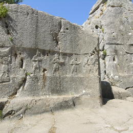
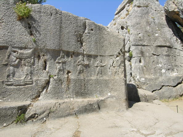
At its largest, the city spread over a sloping, uneven plateau, covering 2.1 km from north to south and 1.3 km from east to west. In the 13th century, the city was surrounded by a system of double walls forming a perimeter of roughly 8 km. It was protected at the east end by the Kayalı Boğäz outpost, 1.5 km from the Royal Gate. To the north, beyond the walls, were located a necropolis cut into the rock at Osmankayası and the great rupestral sanctuary of Yazılıkaya, whose walls decorated with bas-reliefs are the undisputed masterpiece of Hittite art.
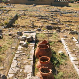
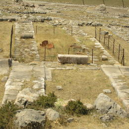
Inside the walls whose most impressive remains lie to the south and the east and comprise primitive Hittite fortifications, with underground passageways, the city is built on two levels. To the northwest, not far from the present-day village of Bogâzkale, which occupies part of the site, is the lower town. The most remarkable monument is the great temple, dedicated to the god of storms and the goddess of the Sun, Arinna, and surrounded by an array of buildings including stores. Thousands of cuneiform tablets were found in this area. Slightly to the north of the temple is the Assyrian settlement’s karum with its houses built around a central courtyard. Part of it dates back to the pre-Hittite period. To the south is located the upper city, a complex layout. The most important element is the royal residence of Büyükkale, a veritable palace-citadel perched upon the main peak.
It is on other fortified peaks the area between the Lions’ Gate to the west and the Royal Gate to the east (the only well-preserved vestiges of the five original monumental entrances) that the best preserved stretches of the double wall are to be found. This wall protected Hattusha, its residential quarters, its palaces and four temples.
| ID | Name & Location | Coordinates | Area | Date Inscribed |
|---|---|---|---|---|
| 377-001 | Hattousa [and Ibikçam Forest] Turkey | N40 0 50.00 E34 37 14.00 | Property: 262 Ha Buffer zone: Ha | 1986 |
| 377-002 | Yazilikaya (rupestral sanctuary) Turkey | N40 1 27.80 E34 38 15.80 | Property: 1.8 Ha Buffer zone: Ha | 1986 |
| 377-003 | Kayali Bogaz (outpost) Turkey | N40 0 11.60 E34 38 14.00 | Property: 4.5 Ha Buffer zone: Ha | 1986 |
| 377-004 | Osmankayasi (rock necropolis) Turkey | N40 1 26.50 E34 37 38.30 | Property: 0.16 Ha Buffer zone: Ha | 1986 |
| Date | Category | Title |
|---|---|---|
| 1986 | Advisory Body Evaluation | Advisory Body Evaluation |
| 1986 | Decision | Report of the 10th Session of the Committee |
| 1986 | Decision | 10COM VIII – Inscription: Hattusha (Turkey) |
| 2006 | Periodic Reporting | (Cycle 1) Section II Summary |
| 2006 | Decision | 30COM 8B.15 – Changes to Names of Properties (Hattusha: the Hittite Capital) |
| 2009 | Map | Hattuşa – Boğazköy |
| 2009 | Decision | 33COM 8D – Clarifications of property boundries and sizes by States Parties in response to the Retrospective Inventory |
| 2014 | Decision | 38COM 8E – Adoption of Retrospective Statements of Outstanding Universal Value |
| 2014 | Periodic Reporting | (Cycle 2) Section II |
Outstanding Universal Value
Outstanding Universal Value
Brief synthesis
Hattusha: the Hittite Capital is located in the Boğazkale District of Çorum Province, in a typical Northern Central Anatolian Mountain region landscape. It lies at the south end of the Budaközü Plain, on a slope rising approximately 300 m above the valley, and is divided by the Kızlarkayası creek into the lower city in the north and the upper city in the south.
The property consists of the Hittite city area, the rock sanctuary of Yazılıkaya on the north, the ruins of Kayalı Boğaz on the east and the İbikçam Forest on the south. A massive enclosure wall of more than 8 km surrounds the city. There are remains of older walls around the lower city and section walls dividing the large city area into separate districts. The ruins of the upper city’s fortification form a double wall with more than a hundred towers and, as far as is known today, five gateways: two in the west, the Lion’s Gate in the south-west, the King’s Gate in the south-east and a procession gate, the Sphinx Gate in the south of the city. The latter is on top of a high artificial bastion with stone-plastered slopes, with two staircases leading to the gateway at the top and an arched stone tunnel running underneath. The impressive ruins of fortifications, placed on rocky peaks in the centre of the Upper City, bear witness to the complexity of Hittite rock masonry, and the longest known Hittite hieroglyphic inscription from the Hittite Empire can be found in the Upper City at Nişantepe.
The best-preserved ruin of a Hittite Temple from the 13th century B.C., known as the Great Temple, is located in the Lower City. Other temples of similar date and shape, albeit generally smaller, are situated in the Upper City, which mostly consisted of a temple city for the gods and goddesses of the Hittite and Hurrian pantheon. The remains of a densely inhabited city district were unearthed in the Lower City, where their foundations and arrangement can still be seen in the area north of the Great Temple.
The famous rock sanctuary of Yazılıkaya, an open-air temple with two natural chambers cut into the bedrock, lies 2 km northeast of the capital, on a slope of a mountain barrier. The walls of the rock chambers are covered with the richest and most striking samples of Hittite relief art, featuring gods and goddesses and the figures of the Great King Tuthaliya IV. Kayalı Boğaz, first mentioned in cuneiform inscriptions, is a large fortified settlement located 1.5 km east of the King’s Gate. It may have served as one of the outposts and strongholds in the countryside to watch and control the main roads leading to the city. The İbikçam Forest represents one of the last remaining examples of a dense forest covering the mountains south of the capital in Hittite times.
Hattusha is an archaeological site remarkable for its urban organization, the types of construction and rich ornamentation that have been preserved and for the ensemble of rock art.
Criterion (i): The city’s fortifications, along with the Lions’ Gate, the Royal Gate and the Yazılıkaya rupestral ensemble and its sculptured friezes, represent unique artistic achievements.
Criterion (ii): Hattusha dominated the civilizations of the 2nd and 1st millennia B.C. in Anatolia and northern Syria.
Criterion (iii): The palaces, temples, trading quarters and necropolis of this political and religious metropolis provide a comprehensive picture of a Hittite capital and bear a unique testimony to the now-extinct Hittite civilization.
Criterion (iv): Several types of buildings or architectural ensembles are perfectly preserved in Hattusha: the royal residence, the temples and the fortifications.
Integrity
All the attributes necessary to express the Outstanding Universal Value are located within the property. Given the property’s location, there are no detrimental effects or threats from industrial development. Residential areas are also a considerable distance from the archaeological site and spread to the north and northwest, implying that urban development is currently not a threat to the property. The setting of the property within its natural environment, without any modern impact, has also been maintained.
Authenticity
Combined archaeological research, long-term restoration and preservation efforts of the German Archaeology Institute, in close cooperation with the Turkish authorities, have uncovered a large variety of buildings such as temples, palaces and dwellings, and technical and communal installations such as largely buried granaries and artificial water ponds. Those discoveries gave access to one of the fascinating ancient cities of the Near and Middle East. Although interventions have been carried out for conservation purposes, attributes have largely retained their authenticity in form, design and layout, allowing visitors to experience a Bronze Age metropolis and understand the relations between the buildings. Careful consideration of the use of restoration materials and techniques is needed to ensure that these conditions remain met.
Protection and management requirements
The ancient city area, Kayalı Boğaz and Yazılıkaya are under the protection of National Conservation Law No 2863. The ancient city area was declared a 1st and 2nd-degree archaeological site, while Kayalıboğaz and Yazılıkaya were declared as 1st-degree archaeological sites. Furthermore, the area encompassing Kayalıboğaz, Yazılıkaya and the ancient city was declared 2nd and 3rd-degree archaeological zones, allowing control of all the interventions and supporting the conservation of the inscribed property. The Regional Conservation Council’s approval must be obtained for all physical interventions within the property. Furthermore, the property is located within the Bogazköy – Alacahöyük National Park, which was approved by the 1988 Council of Ministers’ Degree No 13331. This administrative organization guarantees that archaeological, historical, cultural and natural values are protected together to sustain the property’s Outstanding Universal Value. Property conservation and protection are carried out jointly by the Turkish Ministry of Culture and Tourism and the Çorum Museum.
Furthermore, those authorities control all activities relating to the archaeological site and any infrastructural developments in its immediate surroundings. Decision-making is guided by conservation plans for the sites, approved by the Conservation Council’s decisions. These planning tools require systematic review to ensure the long-term protection of the property.